Friday, December 14, 2007

GOTV Demographics and Google Earth

Thanks to gCensus, loading demographic information into Google Earth is a relatively simple process. You can produce a Google Earth KML file to visualize demographic and socioeconomic data from the 2000 U.S. Census -- in some cases down to the census block level.

Let's say you want to pinpoint areas in Green Bay, WI for a door-to-door Latino voter registration drive. According to the 2000 census, there were over 7,000 Latinos in Green Bay. (The Census Bureau estimates that the Latino population has grown to 10,000 in 2007).

We know from the block-group level Wisconsin interactive GOTV map that neighborhoods east of the river have significant concentrations of Latinos. Click here to use the interactive map zoomed to the focus area shown in the graphic below. Areas shaded orange are 20% to 40% Latino.

The FairVote2020 interactive map shows detail only to the block group level (encompassing several city blocks), so the block-level detail available from gCensus can help focus the voter registration effort.

Below is a Google Earth graphic showing more detailed block-level data -- highlighting all census blocks in Green Bay with more than 31 persons who are Latino. These blocks are shaded tan to orange with white boundaries. The map dataset was created from Summary File 1 using the gCensus web form found here.
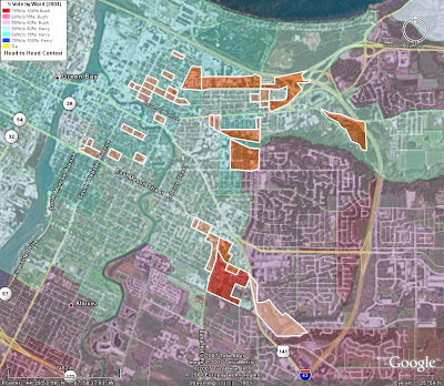

Click here to download the Green Bay Latino KMZ block file -- edited from the original gCensus KML file. The gCensus dataset expresses block population counts as a range, rather than a discrete count. As part of the editing process, we eliminated all but the top three ranges.

In a future post, we will examine an obvious issue -- citizenship status. According to the 2006 American Community Survey, just one-third of the 6,700 Latinos of voting age in Green Bay are citizens.

Note that in order to overlay census blocks on top of the Brown County Bush-Kerry precinct map as in the map above, we changed the altitude settings of the block file to begin displaying at 8 meters.

Because we are focusing on just a couple dozen census blocks, the KMZ file imports into Google Maps with ease.


View Larger Map

For starters, these blocks are the best areas to begin door-knocking in search of new Latino voters.

Saturday, December 8, 2007

2008 Resources

Thursday, December 6, 2007

From Google Earth to My Maps

For neighborhood-level GOTV work, the complete Brown County map displayed in the previous entry is unnecessarily large. But if you have installed Google Earth, you can work with bite-size chunks.

Click on "View Larger Map" in the Brown County Bush-Kerry map, then click on "View in Google Earth".

Start Google Earth and open the Brown_WI.kmz file. Next zoom in to the area of the county where you want to focus your efforts. In the Google Earth graphic below, the view is zoomed to part of Green Bay.


Add a folder under My Places called Green Bay. Next use Ctrl-Left Click on the Brown_WI.kmz map to identify the voting districts of interest. Use Ctrl-Right Click to copy and paste each ward to the Green Bay folder. (You can also copy and paste from the sidebar, without using the map.) Finally, go to the sidebar and copy the legend folder in Brown_WI.kmz to the Green Bay folder.

Save the Green Bay folder as a .kmz file. Go to Google My Maps and select "Create New Map". Next select "Import" and upload the .kmz file from your computer. Your map should look something like this:


View Larger Map


And you are now ready to overlay your own data -- for example, geocoded placemarks showing newly registered voters.

Wednesday, December 5, 2007

Brown County, WI (Bush-Kerry)


View Larger Map

Will Google Maps become a serious neighborhood-level tool for campaigns and voter registration drives in 2008?

It seems easy enough. Just save a base map to Google My Maps, then create an overlay or two with your own data. With Google's new collaboration tool, you can share and edit GOTV maps with coworkers, friends, and volunteers. You can make it public or keep it private.

The map above shows precinct-level results for the 2004 presidential contest in Brown County, Wisconsin. The county has 170 election districts or wards. With so many election districts, the Brown County map tests the limits of Internet Explorer, but displays quickly using Firefox.

To save the Brown County Bush-Kerry map to Google My Maps, click on "View Larger Map".

Saturday, December 1, 2007

10,000 Maps Plus

We produced 30 interactive maps and over 10,000 Adobe PDF precinct maps leading up to the 2004 general election.

Since then, we've updated the interactive maps with precinct-level data for California, Georgia, Minnesota, New Hampshire, New Mexico, South Carolina, Texas, and Wisconsin (plus Maine and Michigan townships).

We'll add more states where we can find statewide precinct-level geographic databases that match the 2004 election results, but in most cases this is not possible. Some additional states may become available as the 2008 election approaches.

Note that several other state map applications include 2002 through early 2004 precinct/precinct proxy voter data -- Arkansas, Florida, Maryland, Michigan, Missouri, North Carolina, Ohio, and Oklahoma.

We've updated the interactive maps with party affiliation maps for Congress and state legislatures to reflect the 2006 election.

Finally, you can now see a Google Map of the area you are viewing on an interactive map. (Google Maps did not exist at the time of the 2004 election.)

For example, click on the graphic below to use a Google Map as an entry viewport to the Georgia GOTV Mapper. Click on FairData (This Win.) or FairData (New Win.) to open the thematic interactive map.


You can switch back and forth by clicking on the balloon icons (representing various zoom levels) beneath the map image on the FairData interactive map.

2004 Precinct KMZ Files

We have produced statewide precinct files in Google Earth KMZ format for eight states -- California, Georgia, Minnesota, New Hampshire, New Mexico, South Carolina, Texas and Wisconsin. You can download them from the Google Earth Community forum.

The precinct boundaries are those in effect for the 2004 election. The maps are themed to show the vote percentages for Bush-Kerry (excluding third party votes).

Use CTRL-Click on the map to display a balloon popup with the voting stats for a specific precinct surrounding or near the clicked point or click on the placemark icon.

Allow some time for the files to load. Except for New Hampshire, the statewide files are way too large for display in Google Maps. However, as we will explain in the next few posts, they can be imported into Google Maps in a piecemeal fashion.